Have Your Say: Soper Hills and Courtice Transit-Oriented Community Secondary Plans
More
![]()
Clarington is committed to responsible growth through careful planning of complete, sustainable and vibrant communities.
On June 19, 2025, beginning at 6:30 p.m., Clarington will present two draft Secondary Plans and their associated Official Plan Amendments – and we want to hear from you!
What is a Secondary Plan? A Secondary Plan is a detailed set of rules and guidelines for developing a specific area within Clarington. It helps determine things like where buildings can go, how tall they can be, what kinds of businesses can operate there, and what kind of roads or parks are needed. Secondary Plans are important because they help make sure the area develops in a way that meets the community’s needs and fits with the rest of the municipality.
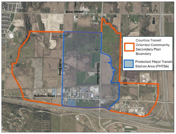
The vision for the Courtice Transit-Oriented Community Secondary Plan includes a mixed-use, transit-supportive community centered on the future Courtice GO Station. It will feature a diverse range of housing with a mix of densities, along with office space, commercial, and industrial uses that will capitalize on the excellent transportation access to the area. The streets will be designed to support active transportation with walkable amenities, street trees, generous sidewalks and bike lanes.
The area will feature new schools and community facilities, access to surrounding natural areas, and a future connection to Lake Ontario and the Courtice Waterfront.
The Courtice Transit-Oriented Community is located south of Bloor Street, north of Highway 401, east of Robinson Creek, and west of Tooley Creek and Highway 418.
The draft plan will be available to review online by May 30, 2025. Click the link to learn more about the Courtice Transit-Oriented Community Secondary Plan.
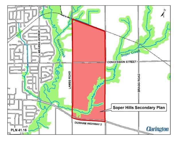
The vision for the Soper Hills Secondary Plan is a compact, connected, and walkable community in east Bowmanville. The plan proposes a variety of housing types, schools, and a network of trails and parks. A neighbourhood centre at the heart of the community will provide convenient access to shopping and services.
Additionally, a community-wide park will serve the recreational needs of both residents and the broader community. Trails will connect with the natural heritage system, creating a comprehensive pedestrian network throughout the neighbourhood.
The Soper Springs Secondary Plan area is located on the east side of Bowmanville. It is generally bound by Regional Highway 2 to the south, Lambs Road to the west, the Canadian Pacific Railway to the north, and Bennett/Providence Road to the east
The draft plan will be available to review online by May 30, 2025. Click the link to learn more about the Soper Hills Secondary Plan.
Review the draft Secondary Plans (available online by May 30, 2025) and join us at Council Chambers, Municipal Administrative Centre, 40 Temperance Street, Bowmanville or attend virtually by watching the live stream at www.clarington.net/calendar.
Date: Thursday, June 19, 2025
Time: Meeting begins at 6:30 pm (please note there are two items on the Public Meeting agenda)
Place: Online or in person in Council Chambers, Municipal Administrative Centre, 40 Temperance Street, Bowmanville
If you are attending online and wish to speak at the public meeting, please pre-register by completing the online form at www.clarington.net/delegations or contact the Clerk’s Division at 905-623-3379 ext. 2109 or clerks@clarington.net by Wednesday, June 18, 2025, at 3:30 p.m. Once registered, staff will provide further instructions. If you are attending in person, you do not need to pre-register as a delegate to speak at the meeting.
For additional information on how to provide comments, join the interested parties list and more, please visit the project webpages at:
Contact Us


