Soper Creek Subwatershed Study

Project Description

The Soper Creek originates on the Oak Ridges Moraine and has a drainage area of approximately 7,730 hectares (77 square kilometres). The Soper Creek flows southeast across the northern part of Bowmanville and continues southerly along the eastern limits of the Bowmanville Urban Area.

There are four subwatersheds within the Soper Creek drainage basin: Mackie, Soper North, Soper East and Soper Main. This subwatershed study will focus on the areas of the Soper Creek Subwatershed that are located within the Bowmanville Urban Area.

The Subwatershed Study will balance the natural and human environments in areas that are anticipated to experience urban development. These recommendations will guide sustainable development of land.

Phase 2 and 3 study report

The Phase 2 and 3 report provides a strategy and recommendations for protecting and enhancing environmental features in the subwatershed area. These recommendations and strategies, which include vegetative buffers, low-impact development techniques, and stormwater management controls, will inform the drafting of the Soper Hills and Soper Springs Secondary Plans, as well as future development patterns in these areas.

The foundation of these recommendations was the Phase 1 Existing Conditions report, which was completed in December 2022. It characterized groundwater, surface water and ecological resources as well as flooding and erosion, the natural heritage system and headwater drainage features within the study area.

Read the Soper Creek Subwatershed Study Report

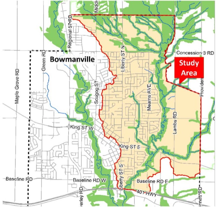
Phase 1 of the Study investigated and inventoried the natural resources which could be impacted by future urban development within the Study area (shown on the map above).  This creates a base of information that will be used to develop stormwater management and natural heritage strategies in the next phase of the Study to protect, rehabilitate, and enhance the environment within the Study area limits.

The Phase 1 (Existing Conditions) Report provides information on groundwater, surface water and ecological resources within the study area, as well as flooding and erosion constraints, the natural heritage system, headwater drainage features and recommendations for further study.

Presentation of key findings from the Phase 1 (Existing Conditions) Report were presented at Public Information Centre #1 (see below).

Over 30 people attended the first Public Information Centre for the Soper Creek Subwatershed Study. Staff and the Municipality’s consulting team, Aquafor Beech Limited and SGL Planning and Design Inc., were on hand to answer questions. Information about existing conditions in the study area, including groundwater, biodiversity, streams, and erosion and natural hazards was presented. 

Staff reports

Background documents

Stay informed and get involved

  • Subscribe to this page to receive email notification when this page is updated with upcoming meetings, surveys and reports.
  • Get in touch with project management staff: Lisa Backus, Manager, Community Planning Division at 905-623-3379 ext. 2413 or email SoperCreeksubwatershed@clarington.net.

Contact Us

Address: 40 Temperance Street, Bowmanville, ON L1C 3A6

Phone: 905-623-3379
TTY: 1-844-790-1599